It has been said that a picture is worth a thousand words, if so, then surely a map is worth even more! While the National Capital Region Transportation Planning Board’s (TPB) Visualize 2045 Long-Range Transportation Plan Update integrates maps into the plan report itself, an interactive Story Map – which contains several sub-topic maps – and an interactive project map provide geographic tours of responses received during the Voices of the Region public engagement activities and the plan’s transportation project list. This post takes a closer look at the maps and how they highlight transportation needs around the region as well as the projects planned to meet these needs over the next 23 years.
Voices of the Region Story Map
As part of the Visualize 2045 update, the TPB conducted public engagement known as ‘Voices of the Region.’ The role of Voices of the Region was to gather public opinion on issues important to the TPB, provide a more nuanced understanding of how regional transportation policies affect people in our region, and to highlight voices that have been underrepresented in the past.
A Voices of the Region public opinion survey took place in 2020. Over 2,400 individuals regionwide participated in the survey. Within the overall Story Map is a topic map displaying answers to the public opinion survey question, “What transportation investments should we make today that future generations will thank us for tomorrow?” Clicking on each data point opens a comment gathered from a survey respondent.
The second part of Voices of the Region outreach consisted of 11 focus groups with 112 people who shared their beliefs, experiences, and perceptions about daily travel. Focus groups discussed equity, safety, and climate. Comments received are mapped by jurisdiction, providing an indication of how place of residence and commuting needs have a role in forming opinions about each of the three topics. To better understand comments by topic, one of the story maps separates remarks into the three categories: equity, safety, and climate. Readers can use the left-right arrows to navigate the maps that provide public perspectives on equity, safety, and climate within the context of transportation.
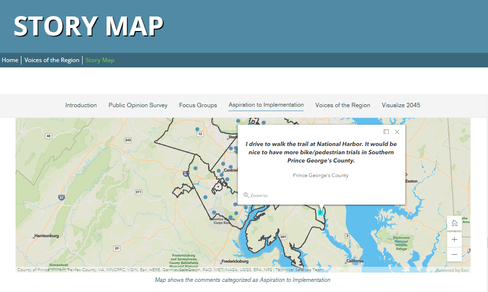
In the summer of 2021, the TPB completed the third phase of its public input process. Using strategically placed posters with QR codes at 40 locations, participants were asked to provide their thoughts on how transportation projects, programs, and policies that align with TPB priorities, called Aspirational Initiatives, impact their lives. Locations selected for posters spotlighted the following initiatives:
- Bringing jobs and housing closer together through transportation
- Expanding bus rapid transit and transitways
- Moving more people on Metrorail
- Providing more commuting and telecommuting options
- Expanding the express highway network
- Improving walking and biking access to transit
- Completing the National Trail Network
Over 400 individuals participated in the QR code activity. On the Story Map, all public input that relates to one of the Aspirational Initiative categories is brought together and tagged. With the map’s filter tool, users can view comments by category. By default, the map shows all comments received. By toggling the map buttons on and off, one or more categories can be viewed, and the map will adjust to zoom to the extent of the selected category or categories. For example, if one wants to see only comments that pertain to expanding the National Capital Trail Network, those comments can be isolated. An example from a respondent who lives in Prince George’s County is shown on the Aspirational Initiatives map below, highlighting the comment, “I drive to walk the trail at National Harbor. It would be nice to have more bike/pedestrian trails in Southern Prince George’s County.”
Interactive Project Map
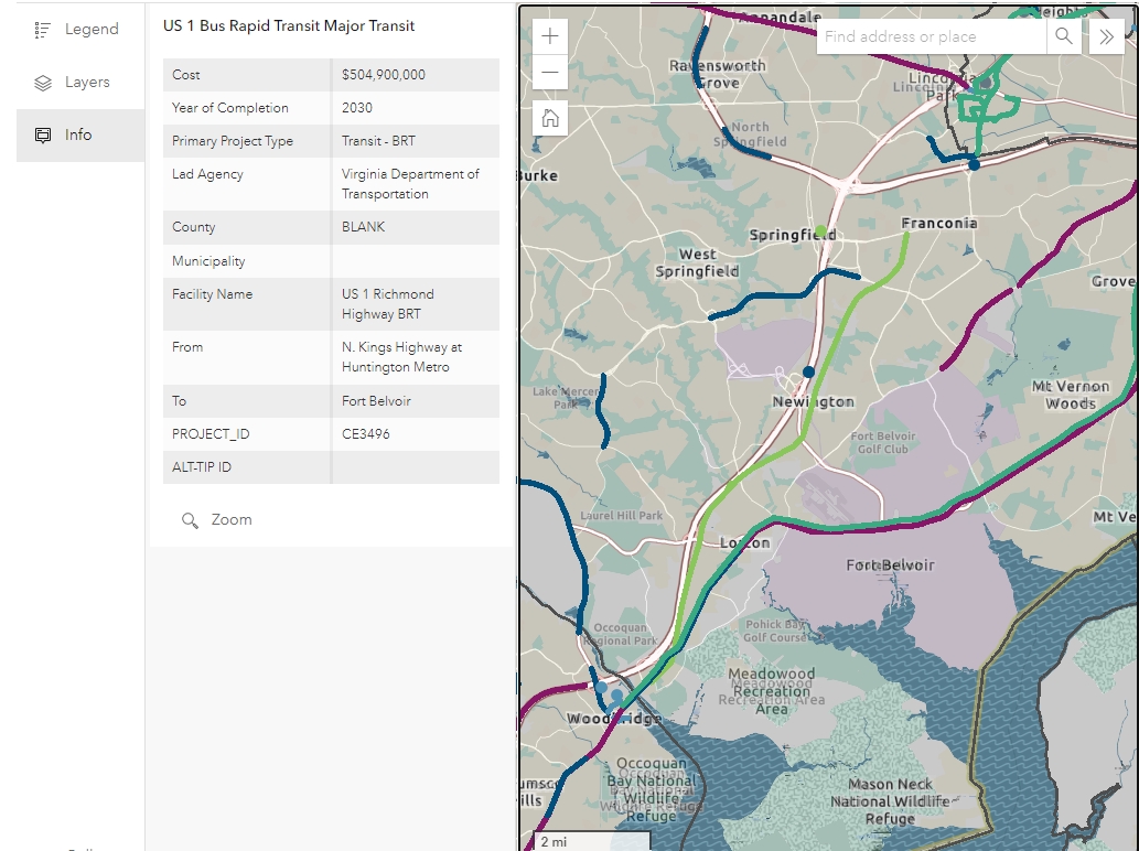
In addition to the Story Map, Visualize 2045 features a map of regionally significant projects which includes those projects that are part of the financially constrained element of the draft plan update—a subset of projects, policies, and programs of the entire portfolio of transportation projects across the region.
What does financial constraint mean? Federal regulations require that the Visualize 2045 financial plan demonstrate that all the projects and programs solicited in the long-range transportation plan can be implemented. All expenditures in the Visualize 2045 plan must be reconciled against reasonably expected revenues, which demonstrates financial constraint.
The types of projects in the constrained element are based on the inputs required for the region’s air quality conformity analysis, a key part of the long-range plan process. These are typically road and transit improvements, although the projects may include freight and bicycle or pedestrian enhancements. Due to the nature of the analysis, there are few stand-alone bicycle and pedestrian projects in this aspect of the plan.
The interactive map’s legend explains the color coding of project categories: road project, road project type, transit project by type, and bicycle & pedestrian projects. As seen in the Richmond Highway Bus Rapid Transit project example below, after clicking on the feature on the map, a table appears listing the relevant details about the project, including the cost, anticipated year of completion, project type, sponsor, and project ID.
Visualize 2045 maps represent just a few of the interactive maps available from TPB. To explore additional Visualize 2045, High-Capacity Transit Station Area, Equity Emphasis Area, and National Capital Trail Network maps, visit COG’s Featured Maps page.
Visit the Visualize 2045 website to learn more about Visualize 2045, view the draft plan update, FY 2023–2026 Transportation Improvement Program, and Air Quality Conformity Analysis.
More information on bicycle and pedestrian projects in the region is available through the TPB’s 2022 update of the Bicycle and Pedestrian Plan for the National Capital Region.