Editor's note: This post has been updated to include the list of Transit Access Focus Areas as approved by the TPB at its July meeting. Read more.
Better paths for walking and biking are important everywhere. But we also know that certain places need greater focus to do the greatest good. The TPB’s Transit Within Reach project has developed a list of 49 Transit Access Focus Areas (TAFAs) as a way to prioritize those places with the greatest need for improvements to make it easier for people to walk and bike to transit. The TPB will be taking up this list for approval at its July meeting.
This work is rooted in the region’s long-range transportation plan, Visualize 2045, which was approved in 2018. Among the plan’s seven aspirational initiatives was a call for the region to make it easier for people to bike and walk to transit. The TPB urged regional leaders to take action to implement this and the other aspirational initiatives. To help turn the concept into reality, TPB staff conducted the Transit Within Reach study.
Read more about the Visualize 2045 aspirational initiatives.
How did we develop the list?
Staff started the study with a baseline list of 208 high capacity transit stations and a few bus-only centers. High capacity transit stations include Metrorail, commuter rail, bus rapid transit, light rail, and streetcar lines. Staff only considered stations that are currently built or will be in place by 2030. In addition, the baseline only included those stations that are within a half-mile of COG’s activity centers. These are regional hubs where people live, work, and play.
Working from this baseline list of station areas, TPB staff began the analysis by asking “where is it difficult to walk?” To answer this, they identified areas around transit stations called walksheds. A walkshed is a way that planners analyze the area around a fixed point—in this case a transit station—and look at how many easy pathways there are for people walking to that point. Physical barriers to those pathways from highways, train tracks, or fences make the walkshed smaller, while more through-streets and fewer barriers create more pathways and create a larger walkshed. Mapping these walksheds were the first step to identifying which stations might have the greatest need.
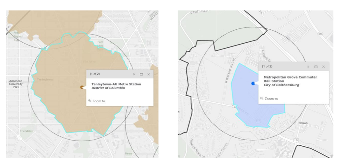
Staff mapped out areas around transit station to identify where it is easier or harder to walk to transit. These are examples of walksheds that show how many pathways there are to a fixed point, in this case a transit station. (TPB)
As the second part of the process, staff asked “Where is there demand for walking and biking?” To answer this, staff identified the station areas that are expected to have large concentrations of jobs and housing in the next ten years.
Finally, the analysis asked, “where are vulnerable populations located?” To answer this, staff identified the station areas located in Equity Emphasis Areas, which are places throughout the region with high concentrations of minority and low-income communities. Out of the 208 station areas selected for analysis, 164 are in Equity Emphasis Areas. In the final TAFA list, 43 out of 49 selected areas are in EEAs.
After developing a draft list, staff worked with the TPB’s member jurisdictions to get local input. One takeaway from those meetings was that the walksheds did not always show what planners expect the area to look like in the future. Staff were able to take the input from this local outreach into account as they finalized the list.
Staff devised a method for allocating the number of TAFAs to each jurisdiction that would be balanced. The larger jurisdictions, which have the vast majority of transit stations, received the greatest number of areas on the list. But every TPB member jurisdiction that has a high capacity station area in its borders was guaranteed to have at least one TAFA on the list.
Here are the Transit Access Focus Areas
The Transit Within Reach Study has produced a draft list of 49 Transit Access Focus Areas in 17 of the TPB’s jurisdictions. The TAFAs lie along a variety of different transit systems, including existing Metrorail and commuter rail lines, as well as forthcoming projects, such as the Purple Line and Silver Line (Phase II). Some TAFAs are located along future BRT lines in Montgomery and Fairfax counties. Two bus-only transit centers are also included.
The Transit Within Reach project is designed to draw attention to the land around stations, not the stations themselves. All the TAFAs are in Activity Centers where pedestrian, bicycle and other micromobility improvements—like scooters and bikeshare—will increase circulation and economic vibrancy, indirectly creating impacts much broader than only improving access to transit.
This list is a starting point and the TAFA geographies were not designed to be interpreted in a rigid manner. Staff conceived these areas as circles of land within a half-mile of a station—which is the distance that most people can comfortably walk. But in some cases, projects outside these circles, especially pathways to improve bicycle access, can have a significant impact. Such projects should be encouraged. Finally, the list is not written in stone. The TPB has not committed to revising the TAFA designations at a specific time, but the list may be updated in the not too distant future, as conditions change.
You can explore the TAFA in an interactive map.
The TPB will take up the TAFA list for approval at its July meeting.
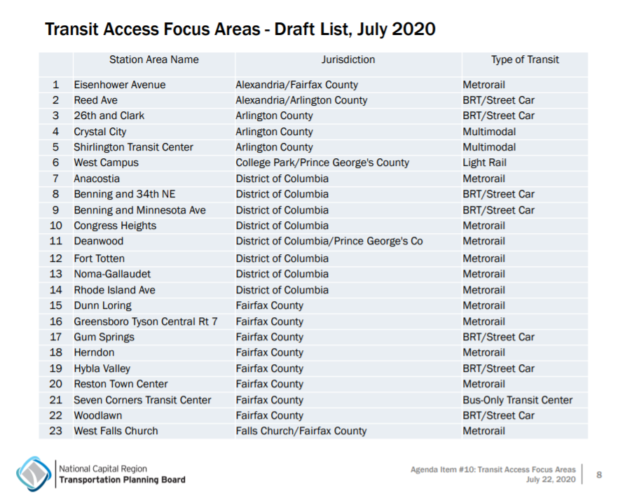
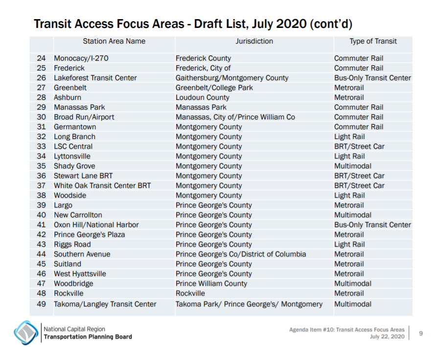
Here is a full list of the TAFA: