How far are you willing to walk to a Metro station? How much time are you willing to spend getting there?
Planners assume that on average, a person can be expected to walk about ten minutes to get to a destination like a train station. That’s typically about a half mile in a straight line.
If we walked in that straight line – or “as the crow flies” -- the outer limits of a half-mile walk would form a perfect circle with the station at the center. But in the real world, as we navigate our way to or from a Metro station, ten minutes of walking often doesn’t get us as far as we would like. Blocks are sometimes very big, sidewalks may be missing, or a natural or man-made barrier may obstruct a direct path. As routes become more circuitous, the area covered by a ten-minute walk is often much tighter than the half-mile radius would suggest.
A walkshed is the area around a station – or any central destination -- that is reachable on foot for the average person. An analysis of “walksheds” can help us understand the difficulties of walking to and from central points, like transit stations.
Sometimes the communities around station areas—typically those with smaller blocks and fewer barriers to walking—have fairly extensive walksheds. But at other stations, with large blocks, natural or man-made barriers to walking the distance that an average person will be able to walk can be a small fraction of the half-mile radius. Such constrained walksheds can be expanded with new pedestrian connections and enhancements to existing connections.
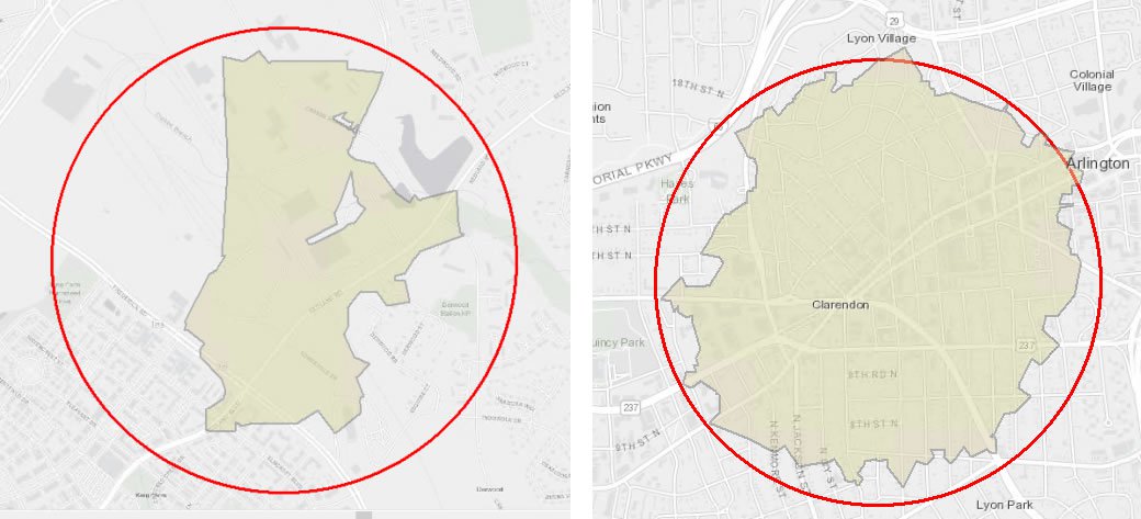
The graphic [below] shows two contrasting walksheds in our region. Much of the area around the Shady Grove station is cut off by Frederick Road (MD 355) and options for walking to the station are limited. Only 17% of the area within a half mile of this station is deemed walkable. In contrast, the neighborhoods around the Clarendon Metro Station have lots of small blocks and a variety of paths to transit. More than 70% of the area within a half mile of the Clarendon station is walkable.
TPB staff have recently produced a dataset of walksheds for all the “high capacity” transit stations in our region. These stations, numbering 199 total, include Metrorail, commuter rail, streetcar, and bus rapid transit. To identify the walkshed for each station, staff performed geospatial analysis using ArcGIS software. For each station, the percent of walkshed coverage within a half-mile for each station was calculated.
You see view the walksheds at mwcog.org/transitwithinreachmap. Viewers can learn the percent coverage for each station here and also see how the built environment around each station influences the shapes of the walksheds. These data can be used to support activities to help expand opportunities for walk or bike access to the station.
The walkshed analysis has been a key part of a new TPB project to support the aspirational initiative in the region’s long-range transportation plan (“Visualize 2045”) to improve walk and bike access to transit. The project involves developing a limited list of transit station areas that will be regionally prioritized for pedestrian and bicycle investments. These prioritized locations will be places where there is an opportunity to increase pedestrian and bicycle connections and where demand could be great for walking and biking to transit.
The walkshed analysis is being used to identify those station areas with deficient infrastructure for walking and biking.
John Swanson, Nicole McCall, and Charlene Howard wrote and contributed to this article.