At its May meeting, the TPB approved 13 projects for $680,000 in technical assistance as part of this year’s Transportation Land Use connections (TLC) program. These projects align with regional priorities, such as promoting walkable, bikeable, and transit accessible communities, and the TPB’s Visualize 2045 aspirational initiatives.
This year, the TLC program received a record number of applications, 25 in total. Solicitation for this year’s projects began in February and ended on April 2, 2019. Applicants demonstrated how each project focused on TPB priorities. The TPB has called on local, state, and regional leaders to “think regionally and act locally” with these projects.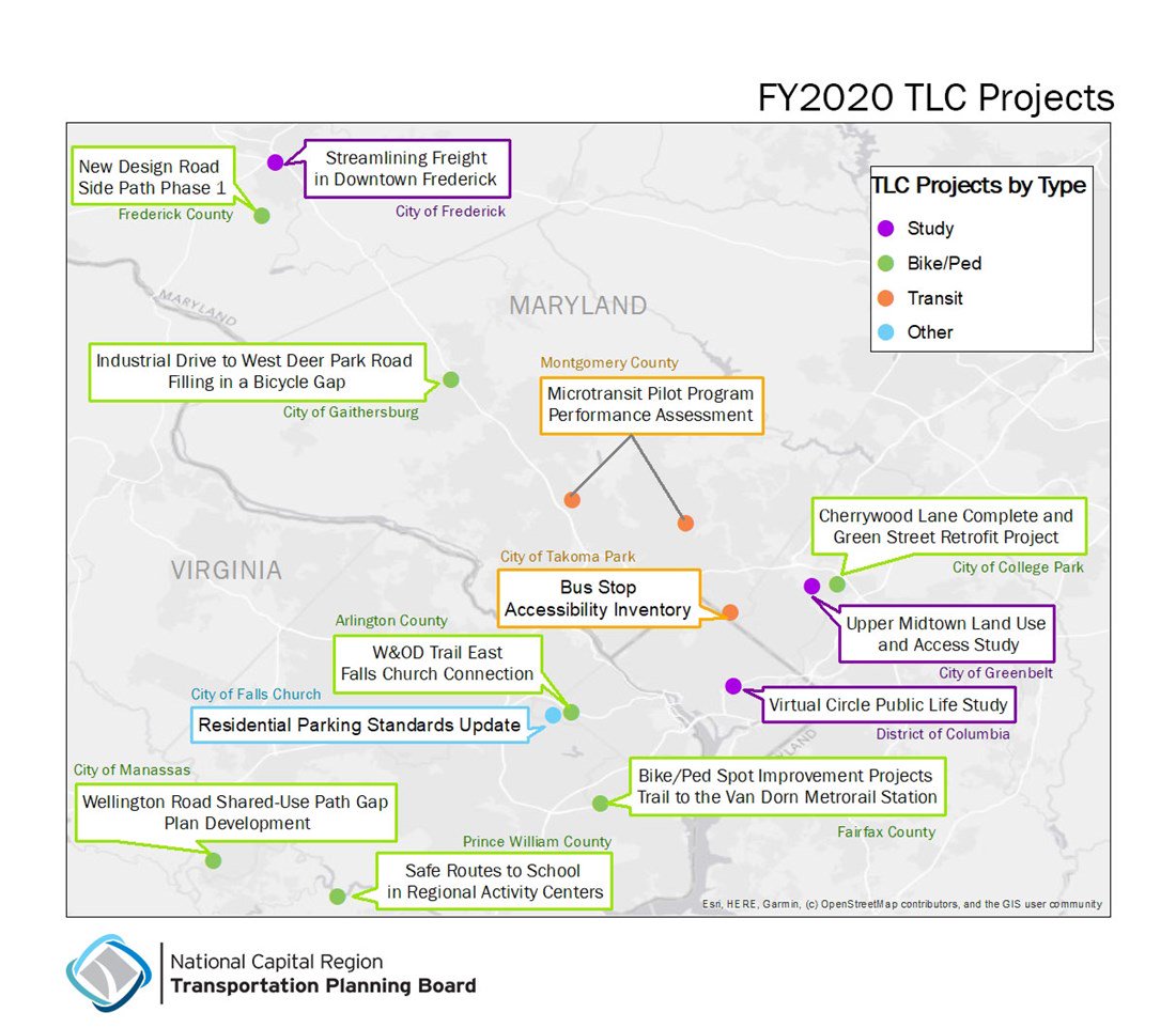
Learn more about this year’s TLC projects and how they will help the region:
District of Columbia - Public Life Study at Florida and New York Avenues
The District is committed to addressing the chronic mobility and safety issues at the New York Avenue and Florida Avenue intersection. The complicated intersection, that creates a “virtual circle” with Wendy’s located in the center, lacks existing data for how pedestrians and bicyclists use the space. Through this project, the D.C. Office of Planning will lead a public life study to gather observational data to better understand how people currently use and would like to use the area both for mobility purposes and as a public space.
City of Frederick -- Streamlining Freight in Downtown Frederick
Understanding the current and future of freight delivery in a vibrant historic downtown is needed to strengthen the City of Frederick’s planned update of its comprehensive plan. This project will provide data on where delivery trucks currently park or sit by the curb and how many are expected in the future. The city is also looking for policy suggestions and best practices. The data will help the City of Frederick by forecasting future freight location needs and identifying enforcement considerations.
College Park -- Upper Midtown Land Use and Access Study
Investment in College Park’s three-mile Route 1 corridor has brought new density and improved multi-modal connectivity. However, areas to the north of Greenbelt Road/MD 193 experience high-speed limits, heavy traffic volume, and limited sidewalk and bicycle facilities. This study would provide the city with technical assistance to begin solving these critical challenges. Outcomes of this project will include recommendations to model potential redevelopment scenarios and infrastructure improvements that are needed for this type of transformation in the city and the region.
Frederick County - New Design Road Side Path Phase 1
One of Frederick County’s goals is to develop a coordinated multi-modal transportation system by integrating transit, pedestrian, bicycling, and Americans with Disabilities Act (ADA) accessible facilities into the county’s existing roadways and communities. This project is the first of three phases for a side path along New Design Road. This side path will eventually connect the City of Frederick with the C&O Canal National Park, which in turn connects to the National Capital Trails network on a protected path.
City of Gaithersburg - Concept and Feasibility Study: Industrial Drive to West Deer Park Road – Filling in a Bicycle Gap
Bicycle connections in the City of Gaithersburg’s bicycle network are needed to address bicycling on the heavily traveled MD 355 Frederick Road. This project will conduct a concept and feasibility study to connect Industrial Drive to West Deer Park Road. This connection would provide a less stressful alternative route away from busy car traffic for many bicyclists.
Greenbelt - Cherrywood Lane Complete and Green Street Retrofit Project
Cherrywood Lane connects major destinations to the Greenbelt Metro and MARC Stations. The project will help develop a design for a complete and green street retrofit project to reconstruct a 3,500 ft segment of Cherrywood Lane. This project will serve to provide safe and convenient access for multiple modes of transportation for pedestrians, bicycles, buses, and motorists. The region will benefit from learning the best practices for retrofitting existing roadways into complete and green streets, while providing stronger land use connections for pedestrians and bicyclists.
Montgomery County -- Microtransit Pilot Program Performance Assessment
This summer, Montgomery County Department of Transportation will implement its first pilot microtransit service, called Ride On Flex. This service will provide a new and non-traditional transportation option that connect households, transit hubs, commercial centers, and jobs. Ride On Flex will offer on-demand bus trips in response to requests made on a mobile application for travel within the pilot areas of Wheaton, Glenmont, and Rockville. This project will provide a performance assessment to use information collected from the pilot program to inform future planning efforts to develop similar on-demand transit services.
City of Takoma Park - Bus Stop Accessibility Inventory
The City of Takoma Park plans to expand and support multi-modal transportation options throughout the city, including expanding its bikeways network and bikeshare stations. This project aims to inventory all bus stops in the City of Takoma Park with a focus on ADA compliance, accessibility, and bicycle and pedestrian facilities to establish regionwide connectivity. It will include an inventory of amenities to determine actionable priorities for improving bus stops in the area, and a set of recommendations to support increased transit usage and accessibility.
Arlington County - W&OD Trail East Falls Church Connection
The W&OD Trail is a regional pedestrian and bicycle trail with 3,000 plus daily users. This trail is used for walking and bicycling to the East Falls Church Metrorail Station and for longer-distance bicycle commuting across the area. The only gap in the 45-mile long W&OD Trail is in East Falls Church. The trail gap creates conflicts involving trail users and motorized traffic. This project will use technical assistance to identify alternatives for constructing an off-street connection of the trail sections in the East Falls Church area.
Fairfax County -- Bike/Ped Spot Improvement Projects - Trail to the Van Dorn Metrorail Station
Fairfax County hopes to ease access to high capacity transit, create a more continuous and viable network of bicycle and pedestrian facilities, and support multi-modal travel. This project will receive technical assistance to complete preliminary designs and create cost estimates for a series of projects to improve the trail connections to the Van Dorn Metrorail Station. The work will include several spot projects, such as path widenings and neighborhood connections.
City of Falls Church - Residential Parking Standards Update
The City of Fall Church is currently part of an effort to address overbuilding of parking and underinvestment in multi-modal transportation options. This project will update multi-family residential parking requirements for new development in the area. An outcome of this project will include revisions to the city’s Traffic Impact Analyses tables, which are used to estimate potential traffic impacts of proposed land uses and assign parking requirements. The project will also support a potential revision to the city’s zoning ordinance. The updated standards would be intended for use in all future multi-family residential projects and useful to other jurisdictions in the region.
City of Manassas - Wellington Road Shared-Use Path Gap Conceptual Plan Development
The Wellington Shared Use Path is a major connection to regional and national bike connections within Prince William County. This project will address safety, connectivity, and accessibility by providing a safe connection over the railroad tracks. It will also work to strengthen the local bike network and providing greater access throughout the City of Manassas. The project will develop a preliminary design for a .35-mile section of the Wellington shared-used path between Nokesville Road and Prince William Street.
Prince William County - Safe Routes to School Planning for Regional Activity Centers
Safe Routes to School is an initiative that promotes walking and bicycling to school through infrastructure updates and other strategies. As new housing and jobs are focused into Regional Activity Centers, Prince William County must plan for safe and convenient walking and biking routes to schools. This project will address pedestrian and bicycle gaps in three Regional Activity Centers: Yorkshire, Innovation Park, and North Woodbridge and identify priority routes and potential infrastructure improvements within one-mile of the schools. This project will be coordinated with Prince William’s ongoing development of Small Area Plans and will help address local and regional transportation issues.
About the selection process
A selection panel made up of experts from the National Capital Planning Commission, American Society of Civil Engineers, Urban Land Institute, Transportation Research Board, and American Planning Association along with TPB staff was tasked with narrowing down the projects and coming up with a list of recommended projects for TPB approval.
The recommended projects were selected as the most locally and regionally beneficial across the District of Columbia, Maryland, and Virginia. In addition to the aspirational initiatives, TLC projects also further other TPB priorities, including being in Activity Centers and Equity Emphasis Areas, and providing access to high capacity transit. From the selected projects, 12 are in Activity Centers, 13 are near high-capacity transit, and 9 serve Equity Emphasis Areas.
Activity Centers
Activity Centers are the region’s priority growth areas and include existing urban centers, suburban town centers, traditional towns, and transit hubs. These are places where people can live, work, and play. There are currently 141 Activity Centers in the region. These Activity Centers are expected to play an important role in helping the region accommodate the 1.5 million new residents and 1.1 million jobs anticipated by 2045. For example, the Prince William County Safe Routes to School Planning for Regional Activity Centers project will specifically look at walking and biking to schools in the county’s Activity Centers: Yorkshire, Innovation Park, and North Woodbridge.
Equity Emphasis Areas
Equity Emphasis Areas are small geographic areas that have significant concentrations of low-income, minority populations, or both. For Visualize 2045, the TPB analyzed how the plan would perform comparing Equity Emphasis Areas to the rest of the region. The TLC program encourages potential projects to consider these areas to alleviate disproportionate transportation or land use impacts on low-income and minority populations.
Learn more about the Equity Emphasis Areas and explore an interactive map.
Access to High Capacity Transit
High capacity transit stations include Metrorail, commuter rail, streetcar, light rail, bus rapid transit or other. Improving biking and walking connections to these stations has been identified as one of the TPB’s aspirational initiatives. For example, The Fairfax County Bike/Pedestrian Spot Improvement Project will study biking and walking connections to the Van Dorn Metro Station.
Learn more about the aspirational initiatives focused on biking and walking.
About the TLC program
The TPB initiated the Transportation/Land-Use Connections (TLC) Program in November 2006 to provide support to local jurisdictions as they deal with the challenges of integrating land-use and transportation planning at the community level. Since its start, the TPB has funded 117 technical assistance projects for more than $4.5 million in funding. For more information about completed projects, please visit the TLC website at www.mwcog.org/tlc.
Next steps
Now that the TPB has approved the projects, staff will coordinate with the jurisdictions to begin the consultant selection process. All projects are expected to begin in the Fall after the consultant contracts are signed. The projects will be scheduled for completion by May 31, 2020.
Sarah Bond is the Transportation Land Use Connections intern at the Metropolitan Washington Council of Governments. She is a graduate student at the University of Maryland, pursuing her Masters in Community Planning.