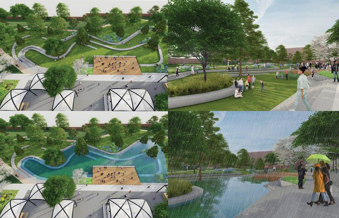
Landsburgh Park Floodable Play Lawn Visualization (DOEE and Ramboll/Moody Graham) Southwest and Buzzard Point Flood Resilience Strategy
In June 2025 COG completed work with the District of Columbia and Prince George’s County, with support from consulting firms ICF, Straughan Environmental, and CHplanning, on a project to address flood concerns across jurisdictional boundaries. The Regional Blue-Green Infrastructure Community Engagement and Planning Project aims to increase resilience in three subwatersheds that span the District of Columbia and Prince George’s County—Watts Branch and Arundel Canal (part of the Northwest Branch) of the Anacostia River and Oxon Run which is part of the Potomac River watershed.
This collaborative project prioritized areas vulnerable to flooding and other social, economic, and environmental stresses. The project focused on engaging traditionally disadvantaged communities in flood prone areas to identify BGI projects that can assist in the mitigation of flood impacts. Through community-driven efforts, the project sought to develop a regional framework to reduce flood risk, provide stormwater capabilities, and increase recreational green space, that can be replicated throughout metropolitan Washington. The project was funded through FEMA's Regional Catastrophic Preparedness Grant Program.
PROJECT BACKGROUND AND GOALS
The project focuses on the two shared subwatersheds of the Anacostia River and one subwatershed of the Potomac River: The two project areas of the Anacostia River are Arundel Canal, a tributary of the Northwest Branch which originates in the District of Columbia and Watts Branch which originates in Prince George’s County. For the Potomac River, the project focus will be the Oxon Run subwatershed. All three project areas share the commonality of flowing between the jurisdictional boundaries of the District and Prince George’s County.
The planning study will identify potential BGI projects intended to reduce flood risk, improve water quality, reduce stormwater volume, add to recreational spaces, and promote environmental sustainability. Blue-green infrastructure refers to the combination of 'blue' water-related functions with 'green' nature-based solutions such as vegetation and parks. The BGI project will address critical urban challenges including flooding and climate change by leveraging natural solutions, enhancing urban biodiversity, improving air quality, and creating recreational spaces that make cities healthier and more resilient. The planning study will also create partnerships for implementation of proposed projects in collaboration with the District and Prince George’s County.
The project aimed to advance the following goals:
- Enhance Flood Resilience through Regional Collaboration: Build upon current flood mitigation efforts in the three watersheds to maximize impact and ensure cohesive regional planning.
- Upstream and Downstream Impact: Reduce upstream and downstream risks by implementing strategies that address the interconnectedness of watersheds, ensuring comprehensive flood risk management.
- Promote Sustainable Development: Integrate natural water systems with green spaces to create healthier, more livable communities.
- Community Engagement: Foster robust community engagement to ensure BGI solutions meet local needs and priorities, focusing on engaging residents, community leaders, and community-based organizations on flood risks, mitigation strategies, BGI projects, and available resources including flood insurance and stormwater management.
- Create a Replicable Framework: Develop an adaptable BGI Planning Framework that can be replicated in other communities across metropolitan Washington.
STAKEHOLDERS AND TIMELINE
Key stakeholders and partners include: COG, the District of Columbia, Prince George’s County, DC Water, and the U.S. Army Corps of Engineers. Community-based organizations, community leaders, residents, and youth groups are actively participating in the community engagement process.
The 15-month project ran from January 2024 until June 2025.
RESOURCES
BGI Final Report June 2025
Blue-Green Infrastructure (BGI) project factsheet (Espanol)
For questions or comments on the project, please contact bgi@mwcog.org.
-----------------------------------------------------------------------------------------------
Past Community Engagement Workshops (in order of most recent):
Regional Open House
Thursday, May 22nd, 2025
Series 3 Workshops:
Join the Metropolitan Washington Council of Governments (COG), DC HSEMA, DOEE, and Prince George’s County at our April 10th virtual workshop!
📅 Virtual Workshop #3 – Thursday, April 10th, 2025
⏰ Time: 6–8 PM (via Zoom)
Learn about flood solutions, Blue-Green Infrastructure (BGI), and how you can help protect your neighborhood from flooding. The virtual workshop is open to residents, business owners, and community members living or working in the Arundel Canal, Watts Branch, and Oxon Run watersheds.
Mount Rainier Nature Center Community Day
Saturday, April 12th, 2025
Time: 11am - 3pm
Location: Mount Rainier Nature Center 4701 31st Pl, Mt Rainier, MD 20712
Seat Pleasant Community Day
Saturday, May 3rd, 2025
Time: 11 am- 4 pm
Location: Goodwin Park 311 68th Place Seat Pleasant, Maryland 20743
What to Expect:
- Learn how Blue-Green Infrastructure (BGI) helps manage flooding.
- Participate in interactive mapping activities to identify flood challenges and opportunities.
Series 2 Workshop Details: Education & Participation
Arundel Canal:
- Monday, March 3 | 6:00 pm to 8:00 pm
- Sis’s Tavern (4512 41st Ave, North Brentwood, MD 20722)
- Register here
- Flyer
Watts Branch:
Oxon Run:
Learn more about the project through the first Flood Ready Communities: Regional Blue-Green Infrastructure Watershed Workshop. Here is a recording of the project background.