Drivers wanting to cross the Potomac River between Fairfax and Montgomery Counties have only one option: the American Legion Bridge on the Capital Beltway. Opened to traffic for the first time in December 1962, the Legion Bridge today carries more than 232,000 cars and trucks a day -- 10% more than it did in 2000, and nearly four times more than it did in 1965.
Recently, Fairfax and Montgomery County officials met to discuss their shared concerns about congestion in the vicinity of the bridge and ways to move more people and goods more efficiently between the two counties.
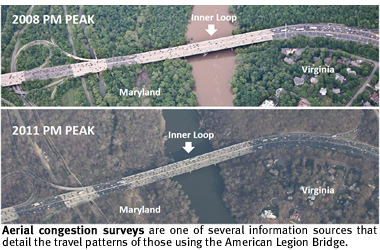
At the meeting, staff from the Transportation Planning Board provided a range of data and information that the TPB has collected detailing the travel patterns of those who use the bridge.
The results of the various surveys and data-collection efforts paint a picture of just how heavily the Legion Bridge is used, how congested it can get and at what times of day, and where the travelers who use the bridge are coming from and going to.
The information includes data gathered by the TPB or the states from in-road sensors that count vehicles, aerial photographic surveys of congestion, voluntary GPS-based monitoring of vehicle speeds, a visual survey of the license plates of vehicles using the bridge, and daily travel diaries collected from a random sample of households throughout the region.
According to the vehicle counts, daily traffic volumes on the bridge have more than quadrupled since it opened nearly 50 years ago, from fewer than 48,000 vehicles a day in 1965 to 232,000 in 2010. The only widening of the bridge took place in 1992, adding one through travel lane and one auxiliary lane in each direction.
An aerial survey of traffic conditions, conducted by the TPB every three years using aerial photography, showed congestion getting worse during afternoon peak travel periods on the Inner Loop span of the bridge connecting Fairfax County to Montgomery County. In the 2011 survey, average speeds on the Inner Loop slowed to between just 15 and 25 miles per hour. On the Outer Loop, the opening in 2005 of a widened ramp to the Dulles Toll Road helped alleviate traffic congestion heading into Virginia, though conditions have once again begun to deteriorate, according to the most recent survey.
 |
Another effort to monitor travel speeds, using GPS-based location information gathered by a private firm from travelers who have agreed to share their information, shows which hours of the day experience the greatest slow-downs on or approaching the bridge. One of the major findings of the survey is that peak travel periods are lasting longer -- a phenomenon known as "peak spreading" -- as more and more drivers try to use the bridge.
The speed data also indicate how much speeds vary on the bridge from day to day -- a key measure of how much extra time those who use the route must budget to make sure they arrive at their final destinations on time -- and help monitor real-time speeds when major incidents like traffic accidents or unexpected weather events cause disruptions.
Finally, two other efforts -- a 2003 license plate survey commissioned by the Virginia Department of Transportation and a 2007/2008 Household Travel Survey carried out by the TPB -- shed light on the origins and destinations of people using the bridge or otherwise traveling between the two counties.
The 2003 license plate survey showed that where drivers were coming from and where they were going were widely dispersed throughout the region and that there was no clear concentration in the origins and destinations of drivers using the bridge.
The survey also found that 30% of vehicles were registered outside the region -- meaning they were probably "through" traffic -- and that 6.5% were commercial trucks.
The Household Travel Survey, carried out in 2007 and 2008, showed that on any given day, more people commute from Montgomery County to Fairfax County than the other way around, although not all of those trips necessarily use the Legion Bridge. The survey found that 2% of commuters traveling from Montgomery County to Fairfax County use transit to get to work, while 9% of people commuting from Fairfax County to Montgomery County used transit, most likely because several major job centers in Montgomery County can be accessed via Metrorail.
Looking ahead, the TPB expects the number of vehicles crossing the bridge each day to continue to increase by about 1% per year. By 2020, speeds on and near the bridge are expected to average less than 10 miles per hour during the most congested parts of the day.
That news adds further urgency to officials' interest in finding new ways to move more people and goods more efficiently across the Potomac River.
One option included in recent TPB scenario studies and presented at the meeting of Montgomery and Fairfax County officials is the extension of the express toll lanes currently being constructed on the Capital Beltway in Virginia. Tolls on the lanes would vary in order to maintain free-flowing traffic throughout the day. Buses, which would travel toll-free on the lanes, would avoid congestion and provide a convenient, reliable travel time for those using transit.
Related Links